迪戈加西亚岛
迪亞哥加西亞島(Diego Garcia)是查戈斯群岛的主岛,也是英属印度洋领地首府所在地,距离印度最南端1900公里。位处太平洋与印度洋的重要国际水域,战略地位重要。查戈斯群島所属島嶼/礁都是英屬印度洋領地。

迪亞哥加西亞島地圖
迪亞哥加西亞島
迪亞哥加西亞島的位置
迪亞哥加西亞島
.jpg.webp)
迪亞哥加西亞島的衛星地圖
_moored_December_1985.jpg.webp)
1985年12月,薩拉託加號航空母艦造訪迪亞哥加西亞島並停泊在港內,成為該島歷史上第一次有航空母艦停靠的紀錄。

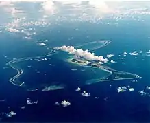
空中鳥瞰一座位於島上東角(East Cape)的椰子園,
歷史
1532年葡萄牙人迪亞哥加西亞到达,1810年被英国占领,为英属毛里求斯属地,1965年成为英属印度洋领地的一部分。1966年英美签订协议后,成为美国在印度洋的重要海空军基地。
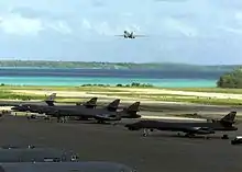
岛上有英美的联合军事基地,但主要是英國租借給美军使用,租約期限本訂2016年,已展延至2036年。由于军事原因,该岛无常驻居民,原住民被英政府驱逐。岛上有数种蟹类。在911事件後,美國對塔利班政權展開軍事行動,此島發揮重大作用,美軍短短6個小時即可飛抵阿富汗。
參見
參考文獻
- International Court of Justice. (PDF). I.C.J. Reports 2019. 2019: 95 [2021-05-22]. (原始内容 (PDF)存档于2022-05-03).
This article is issued from Wikipedia. The text is licensed under Creative Commons - Attribution - Sharealike. Additional terms may apply for the media files.