界址
一塊房地產或不動產,在法律上以界址作為限制。界址可以是地表的不連續地形或地物,如溝渠、河岸、樹籬、牆等類似物;但本質上,法律上的界址是一種概念實體、社會建構,附屬於同樣為抽象概念的財產權實體。
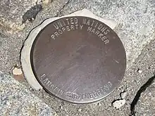
紐約聯合國總部外的土地界標。

中華民國的土地界標。
地籍圖顯示了各單位土地的界址以及其所有者。然而在任何文化或司法管轄區當中,土地、所有者與社會的關係遠比將土地方塊化來得複雜許多。因此,社會體系會明確界址的概念,並制訂規則與手段,將界址予以落實與具體化[1]。
界址認定
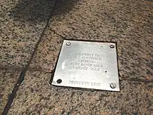
A private property line plaque separating the private property and the public right of way on a sidewalk in New York City. It declares that the public may utilize the space inside the private property by a revocable license, to prevent it to become a prescriptive easement.[2]
法定界址通常會由專業測量員,採用經緯儀與/或現代全球定位系統等手段建立。
在地圖上,界址的界線通常會以「U+214A ⅊ PROPERTY LINE ,HTML:⅊」為標記。
參考文獻
- Turk, Andrew (2007) Representations of Tribal Boundaries of Australian Indigenous Peoples and the Implications for Geographic Information Systems. pp 232 - 244 in Dyson, et al, 2007.
- Jordan, Cora; Randolph, Mary. . (PDF) 2nd. Berkeley: Nolo Press. 1994 [26 July 2014]. ISBN 9780873372664. (原始内容 (PDF)存档于2015-03-18).
This article is issued from Wikipedia. The text is licensed under Creative Commons - Attribution - Sharealike. Additional terms may apply for the media files.