欽邦
欽邦(緬甸語:)是緬甸的一個邦,位於該國西北部。以南北向高山谷地為主。面積36,018平方公里,2005年人口538,000人。首府哈卡。下分2縣。基督徒占钦邦人口的多数,佛教徒占少数。欽邦位于缅甸西部若开邦之北的狭长山地,在东经92.15E-97E与北纬18N-27.30N之间,西南靠孟加拉国,西北与印度曼尼普尔邦为邻。欽邦最高的山叫Khawnutum,最大的河流叫格拉丹(Kaladan)河,最大的湖是丽(Rih)湖。
| 欽邦 ချင်းပြည်နယ် | ||
|---|---|---|
| 邦 | ||
| 轉寫轉寫 | ||
| • 緬甸語 | ||
| ||
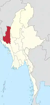 欽邦在緬甸的位置 | ||
| 坐标:22°0′N 93°30′E | ||
| 國家 | ||
| 地區 | 西緬甸 | |
| 首府 | 哈卡 | |
| 政府 | ||
| • 首席部長 | 萨莱连卢伊 (全國民主聯盟) | |
| • 內閣 | 欽邦政府 | |
| • 立法機構 | 欽邦議會 | |
| • 高等法院 | 欽邦高等法院 | |
| 面积[1] | ||
| • 总计 | 36,018.8 平方公里(13,906.9 平方英里) | |
| 面积排名 | 9 | |
| 人口(2014)[2] | ||
| • 總計 | 478,801人 | |
| • 排名 | 14 | |
| • 密度 | 13.3人/平方公里(34.4人/平方英里) | |
| 人口統計 | ||
| • 民族 | 欽族 | |
| • 宗教 | 基督教 85.4% 上座部佛教 13.0% Laipian 1.1% 泛靈論 0.4% 伊斯蘭教 0.1% | |
| 时区 | MST(UTC+06:30) | |
| HDI (2015) | 0.556[3] 中 | |
气温:夏季(4-5月)摄氏15-21度,冬季摄氏4-0度。年降雨量80-120英寸(2032-3048毫米)。南部常有孟加拉湾刮来的台风。
歷史
历任邦长
- 洪艾(2011年3月-2016年3月30日)
- 萨莱连卢伊(现任)(2016年3月30日-)
參考資料
- . City Population. [2009-04-10]. (原始内容存档于2018-12-25).
- . The 2014 Myanmar Population and Housing Census 2. Naypyitaw: Ministry of Immigration and Population. May 2015: 17 [2019-01-18]. (原始内容存档于2019-05-07).
- . hdi.globaldatalab.org. [2018-09-13]. (原始内容存档于2018-09-23) (英语).
- B. S. Carey & H. N. Tuck, The Chin Hills: A History of the People, our dealings with them, their Customs and Manners, and a Gazetteer of their Country, vol. 1 (Rangoon, Burma: Government Printing, 1896), 12-33.
- Ngul Lian Zam (Guite), "Mualthum Kampau Guite Hausate Tangthu" (Amazon/CreateSpace, United States, 2018), 77-152 ISBN 978-1721693559.
- Carey & Tuck, The Chin Hills 1, 17-18, 23-24.
- . Statoids. [18 November 2017].
This article is issued from Wikipedia. The text is licensed under Creative Commons - Attribution - Sharealike. Additional terms may apply for the media files.