Microsoft Streets & Trips
Microsoft Streets & Trips是微软公司基于Microsoft MapPoint技術开发的一款地图程序[2]。该软件最初由NextBase Ltd.公司开发,1988年发布首个版本,该公司于1994年被微软收购。此软件的主要竞争对手是DeLorme公司的Street Atlas系列软件。Microsoft Streets & Trips软件最终于2013年停止更新[3][4],相关支持于2015年停止,接替者是Bing地图[5]。软件的最终版本是2012年7月1日发布的2013 (19.00.18.2600)[6]。该软件有一个配有GPS定位器的套装款(Streets & Trips with GPS Locator),用户可将该设备插入笔记本电脑的USB端口,在旅途中使用导航功能[7]。
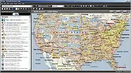 软件的主界面 | |
| 開發者 | 微软公司 |
|---|---|
| 首次发布 | 1988年 |
| 最终版本 | |
| 操作系统 | Windows XP或更新版本[1] |
| 平台 | IA-32[1] |
| 文件大小 | 1.4 GB[1] |
| 类型 | 路線規劃軟體 |
| 许可协议 | 共享軟體[1] |
| 网站 | microsoft |
Microsoft Streets & Trips支持美国、加拿大、墨西哥等美洲国家[2]。名为Microsoft AutoRoute的欧洲版本则覆盖了超过37个欧洲国家[8]。
兼容性
Streets & Trips 2006及此后的版本兼容Windows Vista及后续版本的现代操作系统[2]。
参考文献
- . web.archive.org. 2013-01-15 [2022-04-16]. 原始内容存档于2013-01-15.
- Popa, Bogdan. . softpedia. 2014-07-07 [2022-04-16]. (原始内容存档于2021-10-10) (英语).
- . web.archive.org. 2014-07-11 [2022-04-16]. 原始内容存档于2014-07-11.
- . support.microsoft.com. [2022-04-16]. (原始内容存档于2021-04-22).
- . web.archive.org. 2012-07-07 [2022-04-16]. 原始内容存档于2012-07-07.
- . web.archive.org. 2013-03-07 [2022-04-16]. 原始内容存档于2013-03-07.
- . web.archive.org. 2010-02-04 [2022-04-17]. 原始内容存档于2010-02-04.
外部链接
This article is issued from Wikipedia. The text is licensed under Creative Commons - Attribution - Sharealike. Additional terms may apply for the media files.