马尔蒙-帕沙
马尔蒙-帕沙(法語:)是法国洛特-加龙省的一个市镇,位于该省东南部,与热尔省接壤,属于阿让区和阿让城市圈公共社区。该市镇总面积7.96 平方千米,海拔在103至169米之间,2021年1月1日年时的人口为168人[2]。
| 马尔蒙帕沙 Marmont-Pachas | ||
|---|---|---|
 | ||
| ||
马尔蒙帕沙的位置 | ||
 马尔蒙帕沙 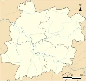 马尔蒙帕沙 | ||
| 坐标:44°05′19″N 0°35′12″E | ||
| 国家 | ||
| 大区 | ||
| 省 | ||
| 面积1 | ||
| • 市镇 | 7.96 平方公里(3.07 平方英里) | |
| 人口(2021年)[1] | ||
| • 市镇 | 168人 | |
| • 密度 | 21.1人/平方公里(54.7人/平方英里) | |
| 时区 | CET(UTC+01:00) | |
| • 夏时制 | CEST(UTC+02:00) | |
| 邮政编码 | 47220 | |
| INSEE | 47158 | |
| 省级选区 | 阿让西部县 | |
| 海拔 | 192米 | |
| 1法國統計部門在計算土地面積時,不計算面積大於1平方公里的湖泊、池塘、冰川和河口。 2「人口不重複計算」:擁有多重居住地的居民(如:學生和軍人)僅計算一次。 | ||


马尔蒙-帕沙市镇地图
马尔蒙-帕沙圣母教堂
交通
洛特-加龙省省道D15线和D282线在马尔蒙-帕沙境内交汇。
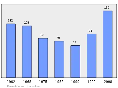
人口
马尔蒙-帕沙人口变化图示
参见
- 洛特-加龙省市镇列表
参考文献
- . 法国国家统计与经济研究所. 2023年4月27日.
- Populations légales 2021年1月1日 (法文)
- https://www.insee.fr/fr/information/3363419; 官方地理代码; 检索日期: 2019年1月6日.
This article is issued from Wikipedia. The text is licensed under Creative Commons - Attribution - Sharealike. Additional terms may apply for the media files.