特隆赫姆峡湾
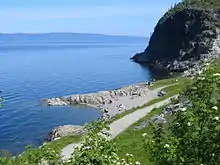
特隆赫姆峡湾[1][2][3] (挪威語:, 发音:[²trɔnːhæi̯msˌfjuːɳ]),它位于挪威西部,分属南特伦德拉格郡和北特伦德拉格郡,是挪威第三长峡湾,长130(81英里)。它北起斯泰恩谢尔,西止于欧兰,中途经过特隆赫姆。其最大深度617(2,024英尺),就在阿格德內斯。


灯塔

峡湾以东和以南的低地是挪威最好的农业区之一。
特隆赫姆峡湾以特隆赫姆命名。
参考
- Chippindale, Christopher, & Paul S. C. Taçon. 1998. The Archaeology of Rock-Art. Cambridge: Cambridge University Press, p. 156.
- Thue, Stein. 2008. On the Pilgrim Way to Trondheim. Trondheim: Tapir Academic Press, p. 27.
- Hamblin, Paul F., & Eddy C. Carmack. 1980. Mean Field Distributions of a Dissolved Substance in the Vicinity of Branches in a Fjord System. In: Howard Freeland et al. (eds.), Fjord Oceanography, pp. 371–376. New York: Plenum, p. 371.
This article is issued from Wikipedia. The text is licensed under Creative Commons - Attribution - Sharealike. Additional terms may apply for the media files.