摩頓灣
摩頓灣(英語:)是位於澳大利亞昆士蘭州府城布里斯本以東19公的一處海灣,約形成於6,000年前,乃昆州最重要的海岸資源[1]。摩頓灣的水域是當地人最常親近的一片天然休閒場所,也是近海漁民賴以為生的地方。
布里斯本港位於摩頓灣之北;廣大平坦的地勢,成為布里斯本機場和噪音汙染的緩衝地帶。由於此處擁有大片的沙灘,水產豐富,所以在歐洲人殖民初期,此地是新移民與澳大利亞原住民經常發生衝突的地方。
歷史
摩爾頓灣大約在6000年前時,因為海平面上升將原本布里斯班河的氾濫平原給淹沒而形成。
摩爾頓灣(澳大利亞原住民稱為Quandamooka)及周邊島嶼最早是澳大利亞原住民所居住棲息的地方, 1770年5月15日庫克船長首次航行通過此地時,以英國皇家學會會長Lord Morton之名命名為Morton's Bay。[2] Moreton的寫法是因為庫克船長的航海紀錄的第一次出版時誤拼所造成[3]。
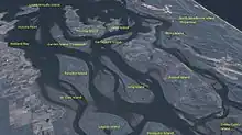
南摩頓灣中的沙洲
參考文獻
- South East Queensland Regional Strategic Group. . 2000: 56. ISBN 0734517408.
- Environmental Protection Agency (Queensland). . State of Queensland. 2000: 4. ISBN 0-7345-1008-X.
- Ray Parkin, H. M. Bark Endeavour, Miegunyah Press, second edition 2003, ISBN 0-522-85093-6, page 226.
外部連結
- 摩頓灣資料庫
- 海灣日誌 An online news source publishing one story a day about the Bay.
- 澳大利亞鄉村歌謠:摩頓灣 (页面存档备份,存于) Folk song about the penal colony at Moreton Bay
- Pencil drawing of Moreton Bay settlement, ca. 1835 by Henry Boucher Bowerman. Digitised and held by Heritage Collections, State Library of Queensland.
This article is issued from Wikipedia. The text is licensed under Creative Commons - Attribution - Sharealike. Additional terms may apply for the media files.