库拉河
库拉河(土耳其語:,喬治亞語:,亞塞拜然語:)是高加索地区最长、流域面积最大的河流,源于土耳其東北部,流经格鲁吉亚(及首都第比利斯),然後進入阿塞拜疆,與阿拉斯河匯合,最後注入裏海。库拉之名源于突厥语 與明格列尔语的 kur(水、河)有關,或是一個意思為「水塘」的古阿尔巴尼亚语名詞。
| 库拉河 Kura | |
| Mt'k'vari, Kür, Cyrus | |
| 河流 | |
[[File: Mtskheta, Mtkvari and Aragvi, Georgia.jpg|293px|none|在姆茨赫塔的庫拉河 {{|}}]] 在姆茨赫塔的庫拉河 | |
| 名称起源:與明格列尔语的 kur(水、河)有關,或是一個意思為「水塘」的古Albanian名詞 | |
| 国家 | 土耳其、格魯吉亞、阿塞拜疆 |
|---|---|
| 地区 | 高加索 |
| 屬於 | 裏海流域 |
| 支流 | |
| - 左侧支流 | 約里河、阿拉扎尼河 |
| - 右侧支流 | 赫拉米河、Tartarchay、阿拉斯河 |
| 城市 | Khashuri、戈里、第比利斯、魯斯塔維、明盖恰乌尔、Zardab、Sabirabad、Neftçala |
| 源头 | 小高加索山脈 |
| - 位置 | 土耳其KarsNear Kartsakhi Lake |
| - 海拔 | 2,740 m(8,990 ft)[1] |
| - 坐标 | 40°40′31″N 42°44′32″E |
| 河口 | 裏海 |
| - 位置 | AzerbaijanNeftchala RayonNeftçala |
| - 海拔 | −26.5 m(−87 ft)[2] |
| - 坐标 | 39°19′32″N 49°20′07″E |
| 长度 | 1,515 km(941 mi)[3] |
| 流域面积 | 198,300 km²(76,564 mi²)[4] |
| 流量 | directly downstream from Aras River confluence |
| - 平均流量 | 443 m³/s(15,644 ft³/s)[5] |
| - 最大流量 | 2,250 m³/s(79,458 ft³/s)[6] |
| - 最小流量 | 206 m³/s(7,275 ft³/s)[6] |
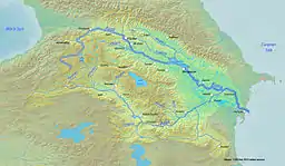 庫拉河流域圖
| |
參考資料
- Guluzada, Lidiya. (PDF). Fondazione Eni Enrico Mattei. [2010-03-12]. (原始内容 (PDF)存档于2011-07-18).
- . Caspian Environment Programme. 2004-11-06 [2010-03-12]. (原始内容存档于2001-04-14).
- . Environmental Conservation and Management. United Nations Development Programme. 2002 [2010-03-12]. (原始内容存档于2008-11-20).
- Mammadov, R.M.; R.Verdiyev. (PDF). United Nations Economic Commission for Europe. 2009-02 [2010-03-12]. (原始内容存档 (PDF)于2011-06-05).
- Rustanov, S. G. (PDF). Institute of Geography of the Academy of Sciences of the Azerbaijan SSR. Symposum on River Morphology. General Assembly of Bern. Commission of Surface Waters. 1967 [2010-04-05]. (原始内容存档 (PDF)于2011-06-20).
- . River Discharge Database. Center for Sustainability and the Global Environment. 1930–1984 [2010-03-12]. (原始内容存档于2010-06-16).
This article is issued from Wikipedia. The text is licensed under Creative Commons - Attribution - Sharealike. Additional terms may apply for the media files.