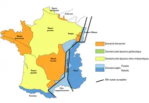
巴黎盆地
巴黎盆地(法語:)是法國的一個沉積盆地,巴黎位于其中心。它由自三叠紀開始的一系列造山运动形成,海拔不超過300(980英尺),西接阿摩里卡丘陵,東临佛日山脈,南抵法國中央高原,北至阿登高地。[1]:252
巴黎盆地
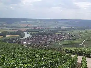
位于盆地中的小鎮屈米耶尔
巴黎盆地南北長達300(190英里),东西跨度更達450(280英里),占據了四分之一的法國國土,覆蓋了诺曼底、巴黎大区、香槟-阿登和洛林大区。有豐富的地下水和天然氣資源[2]。塞纳河及一些运河灌溉著這片土地,當地盛產小麦、甜菜和燕麥,也有畜牧业及釀酒業(尤其以香槟省出名)。[3]
参考文献
- Duval, B.C., 1992, Villeperdue Field, In Giant Oil and Gas Fields of the Decade, 1978-1988, AAPG Memoir 54, Halbouty, M.T., editor, Tulsa: American Association of Petroleum Geologists, ISBN 0891813330
- . 世界之聲. 2014-11-06 [2016-12-04]. (原始内容存档于2019-06-10).
- 巴黎盆地,《地理百科知识博览》,王志艷編,天津人民出版社
- Anon. Carte Géologique de la France à l'Échelle du Millionième ISBN 2-7159-2158-6
- Dercourt, J. 3rd. 2002. ISBN 2-10-006459-2.
This article is issued from Wikipedia. The text is licensed under Creative Commons - Attribution - Sharealike. Additional terms may apply for the media files.