北緯26度線
北緯26度線是地球赤道平面以北26度的纬线。它穿過非洲、亚洲、印度洋、太平洋、北美洲和大西洋。
.svg.png.webp)
26°
北纬26度线
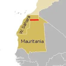
圖中紅線為北緯26度線構成的西撒哈拉與毛里塔尼亚邊界部分。
在這條緯線上,夏至的白晝長13小時46分鐘,正午太阳高度角87.83°,冬至晝長則為10小時31分鐘,正午太阳高度角40.17°。[1]
界線所經
自本初子午線開始、向東,北緯26度線經過以下國家、地區或海域:
參見
- 北緯27度線
- 北緯25度線
參考
- . Astronomical Applications Department of the U.S. Naval Observatory. [2015-08-29]. (原始内容存档于2017-07-18).(英文)
This article is issued from Wikipedia. The text is licensed under Creative Commons - Attribution - Sharealike. Additional terms may apply for the media files.