包厘街
包厘街(英語:,發音: /ˈbaʊ.əri/,當地 /ˈbaʊ.ri/)是美國紐約州紐約市曼哈頓南部的一條南北向街道和小型街區。街區東至艾倫街與下東區,西至包厘街與小意大利,南至運河街與華埠,北至東四街與東村。[1][2]從南到北,與包厘街交匯的主要或知名街道還有德蘭西街、東豪斯頓街以及布利克街。
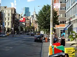
由東豪斯頓街沿包厘街北望帝國大廈
包厘街得名於新尼德蘭殖民地末任荷蘭總幹事彼得·斯泰弗斯特的農場,即,街道由新尼德蘭當時更爲穩定的定居區通往農場[3]。則借譯自這個現代荷蘭語舊詞。1760年時,這條街被叫作包厘巷(),自1807年起以現名爲人所知。[4]
參考資料
- 福多爾公司. . 福多爾公司. 1991年 (英语).
- 福多爾公司. Dailey, Donna , 编. 第五版. 紐約: 福多爾公司. 2012年: 299 [2019年9月4日]. ISBN 978-0-8763-7136-7. (原始内容存档于2016-05-27) (英语).
- Moscow, Henry. 複刻本. 福坦莫大學出版社. 1990年: 29 [2019年9月4日]. ISBN 978-0-8232-1275-0 (英语).
Bowery [–] The Namesake: Peter Stuyvesant's farm or bouwerij, to which the road led from the more settled parts of New Amsterdam. The farm's main house stood between 15th and 16th streets, just east of First Avenue.
- Brown, Henry Collins (编). . 新系列 7. 紐約: Valentine's Manual Inc. 1923年: 70 [2019年9月4日] (英语).
Bowery Lane. The Bowery was called by this name in 1760; since 1807 known as the Bowery.
This article is issued from Wikipedia. The text is licensed under Creative Commons - Attribution - Sharealike. Additional terms may apply for the media files.