俄亥俄州县级行政区列表
美国俄亥俄州由88个县组成。其中九个县在1802年的俄亥俄州制宪大会时就已经存在。 [1]

俄亥俄州诸县
俄亥俄州宪法容许各县像城市村镇一样订立自己的宪章,[2]不过仅有萨米特县和凱霍加縣订立了宪章。[3]
人口数据的来源是2010年美国人口普查。俄亥俄州人口为11,536,502,自2000年普查上涨了1.6%。俄亥俄州的县平均人口为131,096人; 凱霍加縣在俄亥俄州各县中拥有最多的人口(1,280,122人),文顿县的人口最少(13,435人)。县平均面积为464平方英里(1,200平方公里)。 阿士塔布拉縣以702.44平方英里(1,819.3平方公里)居首,而莱克县的面积最小(228.21平方英里,即591.1平方公里)。全州总面积为40,860.69平方英里(105,828.7平方公里)。[4][5]
以下表格会在每一个县的名称后面列出其联邦资料处理标准代码(简称代码),该代码是联邦政府用来区分各州和各县的唯一识别码。这些识别码链接到美国人口普查局关于该县的简介页面。俄亥俄州的代码是39,结合任何一个县的代码则为“”。例如亚当斯县在全国的唯一代码为39001。[6]不过,车辆管理局和交通部则以从1-88的序列数及三个字母的缩写作为各县的代码。[7]
俄亥俄州各县(按英文字母先后排列)
| 县 |
FIPS代码 [6] |
县治 [8] |
成立 [8][9] |
起源 [10] |
词源 [9][10] |
人口 [6][8] |
面积 [8] |
地图 |
|---|---|---|---|---|---|---|---|---|
| 亚当斯县 | 001 | 西尤宁 | 1797年7月10日 | 汉密尔顿县 | 美国总统约翰·亚当斯(1735年-1826年) | 28,550 | 583.91平方英里 (1,512平方公里) |  |
| 艾伦县 | 003 | 莱马 | 1820年3月1日 | 谢尔比县 | 约翰·艾伦 (1771/2年-1813年),1812年战争中担任上校[11] | 106,331 | 404.43平方英里 (1,047平方公里) |  |
| 阿什兰县 | 005 | 阿什兰 | 1846年2月24日 | 韦恩, 里奇兰, 休伦和罗蓝县 | 阿什兰庄园, 美国肯塔基州参议员 亨利·克莱的庄园 | 53,139 | 424.37平方英里 (1,099平方公里) |  |
| 阿什塔比拉县 | 007 | 杰斐逊 | 1807年6月7日 | 杜伦巴尔和吉奥格县 | 阿什塔比拉河,源于阿尔冈昆语“鱼的河流”[12] | 101,497 | 702.44平方英里 (1,819平方公里) |  |
| 雅典县 | 009 | 阿森斯 | 1805年3月1日 | 华盛顿县 | 希腊雅典(俄亥俄大學在前一年設立於此) | 64,757 | 506.76平方英里 (1,313平方公里) | 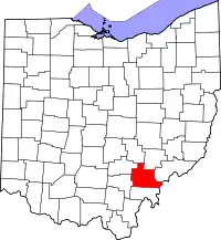 |
| 奥格莱塞县 | 011 | 沃帕科內塔 | 1848年2月14日 | 艾伦县, 默瑟县, Darke, Hardin, Logan, Shelby, and Van Wert Counties | 奥格莱塞河, which means "fallen timbers river" in the Shawnee Indian language | 45,949 | 401.25平方英里 (1,039平方公里) |  |
| 贝尔蒙特县 | 013 | 圣克莱尔斯维尔 | 1801年9月7日 | Jefferson and Washington Counties | Belle monte,源自法语“美丽的山” | 70,400 | 537.35平方英里 (1,392平方公里) |  |
| 布朗县 | 015 | 乔治敦 | 1818年3月1日 | 亚当斯县和Clermont Counties | General Jacob Brown (1775年-1828年),1812年战争军官 | 44,846 | 491.76平方英里 (1,274平方公里) |  |
| 巴特勒县 | 017 | 汉密尔顿 | 1803年5月1日 | 汉密尔顿县 | General Richard Butler (1743-1791), killed at the Battle of the Wabash | 368,130 | 467.27平方英里 (1,210平方公里) | 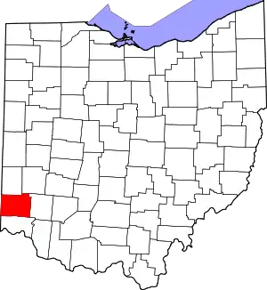 |
| 卡洛尔县 | 019 | 卡罗尔顿 | 1833年1月1日 | Columbiana, Stark, Harrison, Jefferson, and Tuscarawas Counties | 查尔斯·卡罗尔 (1737年-1832年), last surviving signer of the 美國獨立宣言 | 28,836 | 394.67平方英里 (1,022平方公里) | 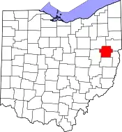 |
| 尚佩恩县 | 021 | 厄巴那 | 1805年3月1日 | Greene and Franklin Counties | French for "a plain", describing the land in the area | 40,097 | 428.56平方英里 (1,110平方公里) | 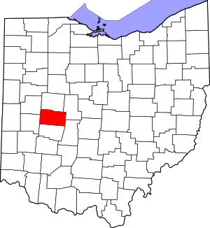 |
| 克拉克县 | 023 | 斯普林菲尔德 | 1818年3月1日 | 尚佩恩县、麦迪逊县和格林县 | 乔治·罗杰斯·克拉克将军(1752-1818)在斯普林菲尔德地区附近的一场战斗中击败了肖尼印第安人 | 138,333 | 399.86平方英里 (1,036平方公里) | 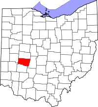 |
| 克莱蒙县 | 025 | 巴达维亚 | 1800年12月6日 | Hamilton County | French for "clear mountain" | 197,363 | 451.99平方英里 (1,171平方公里) | 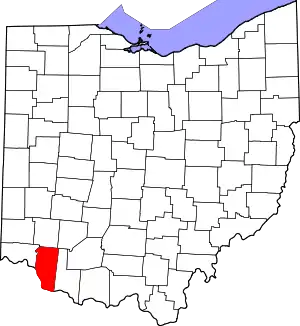 |
| 克林顿县 | 027 | 威尔明顿 | 1810年3月1日 | Highland and Warren Counties | 乔治·克林顿 (1739年-1812年),该县成立时任美国副总统 | 42,040 | 410.88平方英里 (1,064平方公里) | 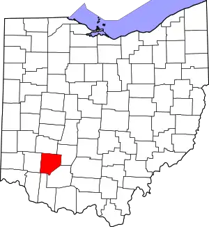 |
| 哥伦比亚纳县 | 029 | 里斯本 | 1803年5月1日 | Jefferson and Washington Counties | 紀念「發現」美洲大陸的克里斯多福·哥倫布 | 107,841 | 532.46平方英里 (1,379平方公里) | 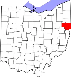 |
| 科肖克顿县 | 031 | 科肖克顿 | 1810年1月31日 | Muskingum and Tuscarawas Counties | Delaware Indian word meaning "union of waters" | 36,901 | 564.07平方英里 (1,461平方公里) | 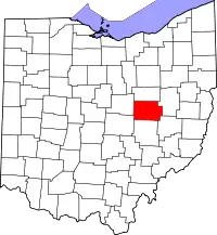 |
| 克劳福德县 | 033 | 布赛勒斯 | 1820年4月1日 | Delaware County | Colonel William Crawford (1732年-1782年),美國獨立戰爭军官 | 43,784 | 402.11平方英里 (1,041平方公里) | 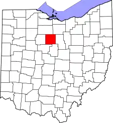 |
| 凯霍加县 | 035 | 克里夫兰 | 1807年6月7日 | Geauga County | 凯霍加河, which means "crooked river" in an Iroquoian language[13] | 1,280,122 | 458.49平方英里 (1,187平方公里) | 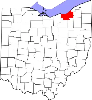 |
| 达克县 | 037 | 格林维尔 | 1809年1月3日 | 迈阿密县 | General William Darke (1736年-1801年),美國獨立戰爭军官 | 52,959 | 599.80平方英里 (1,553平方公里) | 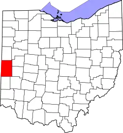 |
| 迪法恩斯县 | 039 | 迪法恩斯 | 1845年4月7日 | Williams, Henry, and Paulding Counties | Fort Defiance, built in 1794 by General Anthony Wayne | 39,037 | 411.16平方英里 (1,065平方公里) | 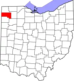 |
| 特拉华县 | 041 | 特拉华 | 1808年4月1日 | 富兰克林县 | Delaware Indians | 174,214 | 442.41平方英里 (1,146平方公里) | 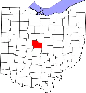 |
| 伊利县 | 043 | 桑达斯基 | 1838年3月15日 | Huron and Sandusky Counties | Erie Indians | 77,079 | 254.88平方英里 (660平方公里) |  |
| 费尔菲尔德县 | 045 | 兰开斯特 | 1800年12月9日 | Ross and Washington Counties | Named for the beauty of its "fair fields" | 146,156 | 505.11平方英里 (1,308平方公里) |  |
| 费耶特县 | 047 | 华盛顿科特豪斯 | 1810年3月1日 | Ross and Highland Counties | Marquis de Lafayette, French military officer and aristocrat who participated in both the American and French revolutions. | 29,030 | 406.58平方英里 (1,053平方公里) |  |
| 富兰克林县 | 049 | 哥伦布 | 1803年4月30日 | Ross and Wayne Counties | 本傑明·富蘭克林(1706年-1791),美国开国元勋、作家、科学家、发明家 | 1,163,414 | 539.87平方英里 (1,398平方公里) | 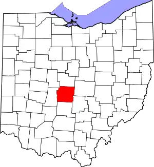 |
| 富尔顿县 | 051 | 沃西翁 | 1850年4月1日 | Lucas, Henry, and Williams Counties | 蒸汽船的發明者羅伯特·富爾頓 | 42,698 | 406.78平方英里 (1,054平方公里) |  |
| 高卢县 | 053 | 加利波利斯 | 4月30日 1803年 | Washington and Adams Counties | 法国九名高卢 | 30,934 | 468.78平方英里 (1,214平方公里) |  |
| 吉奥格县 | 055 | 沙登 | 1806年3月1日 | Trumbull County | An Indian word meaning "raccoon" | 93,389 | 403.66平方英里 (1,045平方公里) |  |
| 格林县 | 057 | 齐尼亚 | 1803年5月1日 | 汉密尔顿和罗斯县 | General 彌敦內爾·格連 (1742-1786), Revolutionary War officer | 161,573 | 414.88平方英里 (1,075平方公里) |  |
| 根西县 | 059 | 剑桥 | 1810年3月1日 | Belmont and Muskingum Counties | 大多数殖民者的故乡根西岛 | 40,087 | 521.90平方英里 (1,352平方公里) | 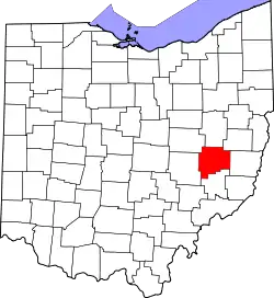 |
| 汉密尔顿县 | 061 | 辛辛那提 | 1790年1月2日 | 创始县之一 | 纪念首任财政部长亚历山大·汉密尔顿 | 802,374 | 407.36平方英里 (1,055平方公里) | 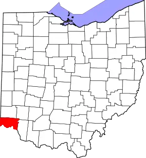 |
| 汉考克县 | 063 | 芬德利 | 1820年4月1日 | 洛根县 | 《美国独立宣言》第一位签署人约翰·汉考克 | 74,782 | 531.35平方英里 (1,376平方公里) | 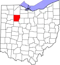 |
| 哈丁县 | 065 | 肯顿 | 1820年4月1日 | 洛根县 | 美国独立战争军官约翰·哈丁 | 32,058 | 470.29平方英里 (1,218平方公里) | 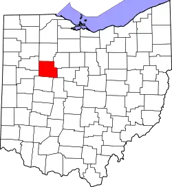 |
| 哈里森县 | 067 | 加的斯 | 1813年2月1日 | Jefferson and Tuscarawas Counties | General 威廉·亨利·哈里森 (1773-1841), an officer of the 1812年战争 and future 美国总统 | 15,864 | 403.53平方英里 (1,045平方公里) | 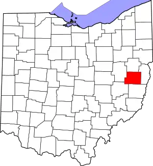 |
| 亨利县 | 069 | 拿破仑 | 1820年4月1日 | 谢尔比县 | 帕特里克·亨利 (1736-1799), Revolutionary War-era legislator, orator, and scholar | 28,215 | 416.50平方英里 (1,079平方公里) | 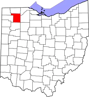 |
| 高地县 | 071 | 希尔斯伯勒 | 1805年5月1日 | Ross, Adams, and Clermont Counties | Descriptive of the county's terrain | 43,589 | 553.28平方英里 (1,433平方公里) | 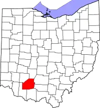 |
| 霍金县 | 073 | 洛根 | 1818年3月1日 | Athens, Ross, and Fairfield Counties | Possibly derived from the Delaware Indian word "Hoch-Hoch-ing", meaning "bottle" | 29,380 | 422.75平方英里 (1,095平方公里) | 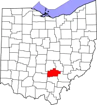 |
| 霍尔姆斯县 | 075 | 米勒斯堡 | 1824年1月20日 | Coshocton, Wayne, and Tuscarawas Counties | Major Andrew Holmes (d. 1814), a 1812年战争 officer | 42,366 | 422.99平方英里 (1,096平方公里) |  |
| 休伦县 | 077 | 诺沃克 | 1809年3月7日 | Portage and Cuyahoga Counties | Huron Indians | 59,626 | 492.69平方英里 (1,276平方公里) |  |
| 杰克逊县 | 079 | 杰克逊 | 1816年3月1日 | Scioto, Gallia, Athens, and Ross Counties | General 安德鲁·杰克逊 (1767-1845), future President of the United States | 33,225 | 420.28平方英里 (1,089平方公里) |  |
| 杰斐逊县 | 081 | 斯托本维尔 | 1797年7月29日 | Washington County | 托马斯·杰斐逊 (1743-1826), Vice President when the county was organized, future 美国总统, and principal author of the Declaration of Independence | 69,709 | 409.61平方英里 (1,061平方公里) |  |
| 诺克斯县 | 083 | 芒特弗农 | 1808年3月1日 | Fairfield County | General 亨利·诺克斯, the first Secretary of War | 60,921 | 527.12平方英里 (1,365平方公里) | 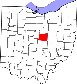 |
| 莱克县 | 085 | 佩恩斯维尔 | 1840年3月6日 | Geauga and 凯霍加县 | Its location on 伊利湖 | 230,041 | 228.21平方英里 (591平方公里) |  |
| 劳伦斯县 | 087 | 艾昂顿 | 1815年12月21日 | Gallia and Scioto Counties | Captain James Lawrence (1781-1813), naval hero in the 1812年战争 | 62,450 | 454.96平方英里 (1,178平方公里) |  |
| 利金县 | 089 | 纽瓦克 | 1808年3月1日 | Fairfield County | Named for the salt licks in the area | 166,492 | 686.50平方英里 (1,778平方公里) |  |
| 洛根县 | 091 | 贝尔方丹 | 1818年3月1日 | Champaign County | General Benjamin Logan (c. 1742-1802), who destroyed Shawnee Indian towns in the county | 45,858 | 458.44平方英里 (1,187平方公里) | 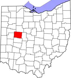 |
| 罗蓝县 | 093 | 伊利里亚 | 1822年12月26日 | 休伦,凯霍加, and Medina Counties | 洛林公国的一个省份 | 301,356 | 492.50平方英里 (1,276平方公里) | 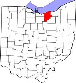 |
| 卢卡斯县 | 095 | 托莱多 | 1835年6月20日 | Wood, Sandusky, and Huron Counties | Robert Lucas (1781-1853), Governor of Ohio when the county was created | 441,815 | 340.46平方英里 (882平方公里) | 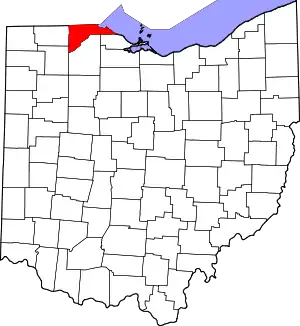 |
| 麦迪逊县 | 097 | 伦敦 | 1810年3月1日 | 富兰克林县 | 詹姆斯·麦迪逊 (1751-1836), fourth 美国总统 | 43,435 | 465.44平方英里 (1,205平方公里) | 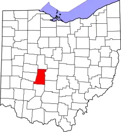 |
| 马霍宁县 | 099 | 扬斯敦 | 1846年3月1日 | Columbiana and Trumbull Counties | Mahoning River, from an Indian word meaning "at the licks" | 238,823 | 415.25平方英里 (1,075平方公里) | 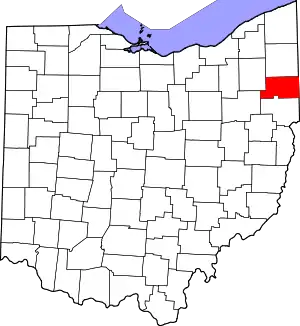 |
| 马里昂县 | 101 | 马里昂 | 1820年4月1日 | Delaware County | General Francis Marion (1732-1795), lieutenant colonel in the 大陆军 and later brigadier general in the 美國獨立戰爭. | 66,501 | 403.84平方英里 (1,046平方公里) | 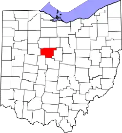 |
| 梅迪纳县 | 103 | 梅迪纳 | 1812年2月18日 | Portage County | 麦地那, world-renowned religious site in western 沙特阿拉伯 | 172,332 | 421.55平方英里 (1,092平方公里) | 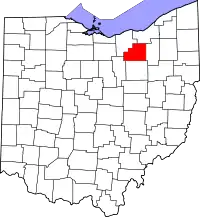 |
| 梅格斯县 | 105 | 波默罗伊 | 1819年4月1日 | Gallia and Athens Counties | 小里滕·J·梅格斯 (1764-1825), Governor of Ohio and Postmaster General at the time the county was organized | 23,770 | 429.42平方英里 (1,112平方公里) | 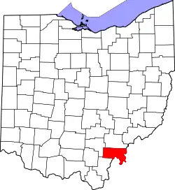 |
| 默瑟县 | 107 | 塞莱纳 | 1820年4月1日 | Darke County | 美國獨立戰爭时期军官Hugh Mercer | 40,814 | 463.27平方英里 (1,200平方公里) | 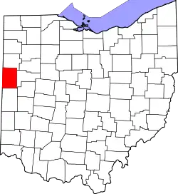 |
| 迈阿密县 | 109 | 特洛伊 | 1807年3月1日 | 蒙哥马利县 | Miami Indians | 102,506 | 407.04平方英里 (1,054平方公里) | 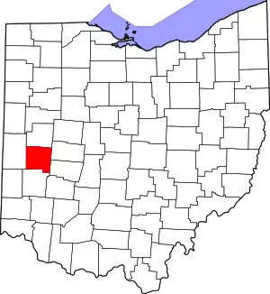 |
| 门罗县 | 111 | 伍兹菲尔德 | 1813年1月29日 | Belmont, Washington, and Guernsey Counties | 詹姆斯·门罗 (1758年-1831年), 该县成立时任美国国务卿,后来成为美国总统 | 14,642 | 455.54平方英里 (1,180平方公里) | 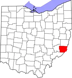 |
| 蒙哥马利县 | 113 | 代顿 | 1803年5月1日 | Hamilton and Wayne Counties | General 理查德·蒙哥马利 (1738-1775), a Revolutionary War officer | 535,153 | 461.68平方英里 (1,196平方公里) | 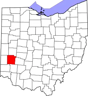 |
| 摩根县 | 115 | 麦康奈尔斯维尔 | 1817年12月29日 | Washington, Guernsey, and Muskingum Counties | General 丹尼爾·摩根 (c. 1735-1802), a Revolutionary War officer | 15,054 | 417.66平方英里 (1,082平方公里) | 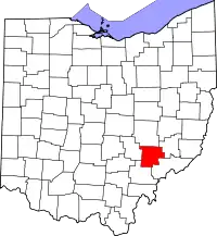 |
| 莫罗县 | 117 | 芒特吉利阿德 | 1848年3月1日 | Knox, Marion, Delaware, and Richland Counties | Jeremiah Morrow (1771-1852), Governor of Ohio | 34,827 | 406.22平方英里 (1,052平方公里) |  |
| 马斯金格姆县 | 119 | 曾斯维尔 | 1804年3月1日[14][15]年 | Washington and Fairfield Counties | An Indian word meaning "A town by the river" or "by the river side" | 86,074 | 664.63平方英里 (1,721平方公里) |  |
| 诺布尔县 | 121 | 考德威尔 | 1851年4月1日 | Monroe, Washington, Morgan, and Guernsey Counties | James Noble (1785-1831), an early settler and future U.S. Senator from 印第安纳州 | 14,645 | 399.00平方英里 (1,033平方公里) |  |
| 渥太华县 | 123 | 克林顿港 | 1840年3月6日 | Erie, Sandusky, and Lucas Counties | Named for the Ottawa Indians; Ottawa means "trader" in their language | 41,428 | 254.95平方英里 (660平方公里) | 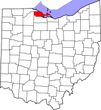 |
| 保尔丁县 | 125 | 保尔丁 | 1820年4月1日 | Darke County | 约翰·保尔丁 (1758-1818),美国独立战争期间捕获间谍约翰·安德烈的士兵之一。 | 19,614 | 416.26平方英里 (1,078平方公里) |  |
| 佩里县 | 127 | 新列克星敦 | 1818年3月1日 | Washington, Fairfield, and Muskingum Counties | Commodore 奧利弗·哈澤德·佩里 (1785-1819), a naval officer of the 1812年战争 | 36,058 | 409.78平方英里 (1,061平方公里) |  |
| 匹克威县 | 129 | 瑟克尔维尔 | 1810年3月1日 | Ross, Fairfield, and Franklin Counties | A misspelling of the Piqua tribe, a branch of the Shawnee | 55,698 | 501.91平方英里 (1,300平方公里) | 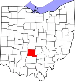 |
| 派克县 | 131 | 韦弗利 | 1815年2月1日 | Ross, Scioto, and Adams Counties | General Zebulon M. Pike (1779-1813), a Revolutionary War officer and discoverer of Pikes Peak in Colorado in 1806 | 28,709 | 441.49平方英里 (1,143平方公里) |  |
| 波蒂奇县 | 133 | 拉韦纳 | 6月7日 1807年 | Trumbull County | Derived from an Indian portage | 161,419 | 492.39平方英里 (1,275平方公里) | 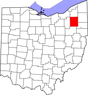 |
| 普雷布尔县 | 135 | 伊顿 | 3月1, 1808年 | Montgomery and Butler Counties | 参加过美国独立战争、的黎波里战争的海军军官爱德华·普雷布尔 | 42,270 | 424.80平方英里 (1,100平方公里) | 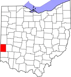 |
| 普特南县 | 137 | 渥太华 | 4月1日 1820年 | 谢尔比县 | 以色列·普特南将军 (1718年-1790年),参加过美國獨立戰爭 | 34,499 | 483.87平方英里 (1,253平方公里) | 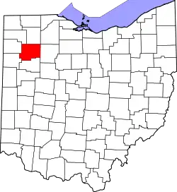 |
| 里奇兰县 | 139 | 曼斯菲尔德 | 1808年3月1日 | Fairfield County | 指的是当地肥沃的土地 | 124,475 | 496.88平方英里 (1,287平方公里) | 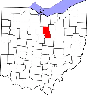 |
| 罗斯县 | 141 | 奇利科西 | 1798年8月20日 | Adams and Washington Counties | Named for U.S. Senator from 宾夕法尼亚州 James Ross by territorial governor 阿瑟·聖克萊 | 78,064 | 688.41平方英里 (1,783平方公里) | 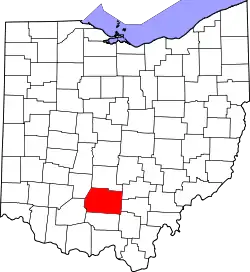 |
| 桑达斯基县 | 143 | 弗里蒙特 | 1820年4月1日 | Huron County | An Iroquois word meaning "cold water" | 60,944 | 409.18平方英里 (1,060平方公里) |  |
| 赛欧托县 | 145 | 朴次茅斯 | 1803年5月1日 | Adams County | 赛欧托河; Scioto is a 休伦族 Indian word meaning "deer" | 79,499 | 612.27平方英里 (1,586平方公里) |  |
| 瑟内萨县 | 147 | 蒂芬 | 1820年4月1日 | Huron County | Seneca Indians, who had a reservation in the county area at the time | 56,745 | 550.59平方英里 (1,426平方公里) |  |
| 谢尔比县 | 149 | 悉尼 | 1819年4月1日 | Miami County | General 艾萨克·谢尔比 (1750-1826), a Revolutionary War officer and Governor of 肯塔基州, | 49,423 | 409.27平方英里 (1,060平方公里) | [[Image:|100px|alt=標示出谢尔比县位置的地圖|標示出谢尔比县位置的地圖]] |
| 斯塔克县 | 151 | 坎顿 | 1808年2月13日 | 哥伦比亚纳县 | 約翰·史塔克将军 (1728-1822), 美國獨立戰爭军官; 因为他在1777年在本宁顿战役中的典范被称为“本宁顿的英雄” | 375,586 | 576.14平方英里 (1,492平方公里) | 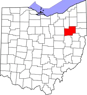 |
| 萨米特县 | 153 | 阿克伦 | 1840年3月3日 | Medina, Portage, and Stark Counties | Its location at the highest elevation along the Ohio and Erie Canal | 541,781 | 419.38平方英里 (1,086平方公里) | 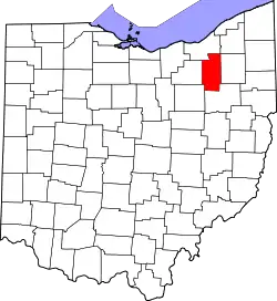 |
| 杜伦巴尔县 | 155 | 沃伦 | 1800年7月10日 | Jefferson and Wayne Counties | Jonathan Trumbull (1710-1785), Governor of Connecticut when the county was organized | 210,312 | 616.48平方英里 (1,597平方公里) | 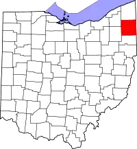 |
| 塔斯卡罗瓦斯县 | 157 | 新费城 | 3月15日1808年 | Muskingum County | 塔斯卡罗瓦斯河, meaning "open mouth river" or the Tuscarawas tribe who lived on the river |
92,582 | 567.58平方英里 (1,470平方公里) | 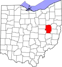 |
| 联合县 | 159 | 马里斯维尔 | 4月1日 1820年 | Delaware, Franklin, Logan, and Madison Counties | Its formation by a union of four counties | 52,300 | 436.65平方英里 (1,131平方公里) | 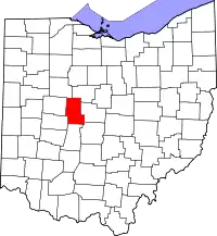 |
| 范沃特县 | 161 | 范沃特 | 4月1日 1820年 | 达克县 | Isaac Van Wart (1760-1828), captor of spy John André during the Revolutionary War | 28,744 | 410.09平方英里 (1,062平方公里) | 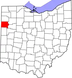 |
| 文顿县 | 163 | 麦克阿瑟 | 1850年3月23日 | Athens, Gallia, Hocking, Jackson, and Ross Counties | Samuel Finley Vinton (1792-1862), Ohio Statesman and U.S. Congressman | 13,435 | 414.08平方英里 (1,072平方公里) | 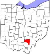 |
| 沃伦县 | 165 | 莱巴嫩 | 1803年5月1日 | 汉密尔顿县 | 約瑟·瓦倫将军 (1741-1775), 美國獨立戰爭军官 | 212,693 | 399.63平方英里 (1,035平方公里) | 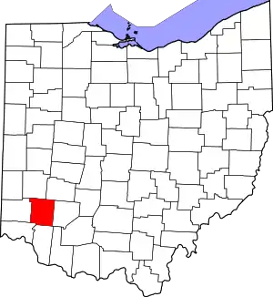 |
| 华盛顿县 | 167 | 玛丽埃塔 | 1788年7月27日 | 最早建立的县之一 | 乔治·华盛顿 (1732-1799), 大陆军总司令, 美利坚合众国制宪会议主席以及后来的美国总统 | 61,778 | 635.15平方英里 (1,645平方公里) | 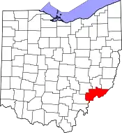 |
| 韦恩县 | 169 | 伍斯特 | 1808年3月1日 | 从非县域重建 | 安东尼·韦恩将军(1745-1796),美国独立战争军官 | 114,520 | 555.36平方英里 (1,438平方公里) |  |
| 威廉斯县 | 171 | 布赖恩 | 1820年4月1日 | 达克县 | 大卫·威廉姆斯(1754-1831),美国独立战争期间抓捕间谍约翰·安德烈 | 37,642 | 421.74平方英里 (1,092平方公里) |  |
| 伍德县 | 173 | 博灵格林 | 1820年4月1日 | 从非县域重建 | 埃利埃泽·D·伍德(1783-1814),梅格斯堡的建立者 | 125,488 | 617.32平方英里 (1,599平方公里) |  |
| 怀恩多特县 | 175 | 上桑德斯基 | 1845年2月3日 | 马里昂县、克劳福德县和哈丁县 | 休伦族印第安人 | 22,615 | 405.61平方英里 (1,051平方公里) | 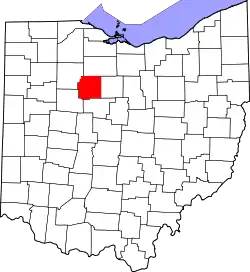 |
参考资料
- Laning, J.F. . Ohio Archaeological and Historical Publications. 1896, V: 326–350 [2015-03-31]. (原始内容存档于2015-11-21).. Other editions available at ISBN 1249686741 and Google Books (页面存档备份,存于)
- Steinglass, Steven; Scarselli, Gino. . Westport, CT: Praeger Publishers. 2004: 272–273. (OH county charter). Other editions available: ISBN 0313267650 and Google Books
- . [2013-02-28]. (原始内容存档于2013-02-25).
- . U.S. Census Bureau. [2013-02-27]. (原始内容存档于2013-03-03).
- . U.S. Census Bureau. December 2009 [2013-02-27]. (原始内容存档于2010-02-23).
- . United States Environmental Protection Agency. [2013-02-27]. (原始内容存档于2012-10-08).
- (PDF). Ohio Department of Transportation. 2013-05-01 [2014-12-21]. (原始内容存档 (PDF)于2015-09-23).
- . [2007-07-22]. (原始内容存档于2007-04-13).
- (PDF). [2013-07-21]. (原始内容 (PDF)存档于2013-07-12).
- Howe, Henry. 2. Columbus, OH: Henry Howe and Son. 1891. (OH county source). Other editions available: ISBN 1425565735 and Google Books (页面存档备份,存于)
- Resolution of 111th Ohio General Assembly designating John Allen as the person for which Allen County was named.
- Ashtabula, 大英百科全书, 2007. Accessed 2007-11-19.
- Cuyahoga River (页面存档备份,存于), 大英百科全书, 2007. Accessed 2007-11-19.
- Downes,第368頁.
- Taylor & Taylor,第40頁.
外部链接
| 维基共享资源上的相关多媒体资源:俄亥俄州县级行政区列表 |
This article is issued from Wikipedia. The text is licensed under Creative Commons - Attribution - Sharealike. Additional terms may apply for the media files.